


See Texas Flash Flood Happen
AND Texas meteorologist explains a Texas flood

This unforgettable video was shot by a time lapse security camera pointed at the Llano River. The Guadalupe and the Llano Rivers are two of many small rivers that rise in the Texas Hill Country, a place of great beauty and frequent flooding. The video begins just after a policeman has stopped traffic heading toward the bridge. You will see drivers stroll down to the bridge and then scurry upwards as the flood hits. This flood took place in April 2025.

Click this link to see video.
This following is the best story I have read explaining why flash floods are so frequent in the Texas hill Country and why they can only be predicted approximately, not precisely.
Here’s why the Texas Hill Country flood was much worse than anyone ever expected
Texas meteorologist explains a Texas flood
By Anthony Franze Gift link
Flooding is the most deadly form of natural disaster in the US, even deadlier than tornadoes. It’s because floodwaters are immensely powerful. Few forces on Earth can match their speed and destructive capacity.
On Friday morning, slow-moving, torrential downpours transformed the Guadalupe River from a gentle stream into a raging, deadly torrent.
Here’s a look at some of the factors that caused this horrific event, and why initial forecasts failed to capture just how extreme the rainfall would be.
On Thursday afternoon, the National Weather Service issued a flood watch for parts of the Hill Country and Edwards Plateau, which included Kerrville. The watch warned the public about widespread rainfall amounts of an inch to 3 inches but forecasters said they “can’t rule out isolated 5 to 7 inches” of rain possible for a few spots.
[Editor's Note: Edwards Plateau is the formal geological name of the Hill Country.]
What unfolded early Friday morning exceeded those expectations by a wide margin. Thunderstorms developed in connection with a weak, slow-moving system of low atmospheric pressure. This system tapped into deep moisture from both the Gulf of Mexico and the remnants of Tropical Storm Barry, which had made landfall earlier in the week on Mexico’s east coast.
The high moisture levels fueled the formation of a mesoscale convective complex over the Hill Country overnight. This type of storm system is often long-lasting and can cause extremely high rainfall rates of more than 3 inches an hour.
Typically, storms that form in this part of Texas move rather quickly over the region, thanks to an active upper-level weather pattern and upper-atmospheric winds. This type of weather pattern leads to quick downpours that often end after 30 minutes or so.
[Editor's Note: This is also true in Houston, where a typical thunderstorm lasts a loud half hour.]
However, in this case, the upper-level pattern was stagnant. With little movement in the atmosphere above, storms at the surface also stalled, dumping enormous volumes of rain over the same area for hours.
[Editor's Note: A similar stagnation occurred in Houston in 2017, when Hurricane Harvey stalled over Houston for 4 days, dropping a total of 58 inches of rain. I was lucky to be on vacation, so I missed spending 4 days inside my house, keeping a lookout for Noah and the Ark.]
The slow movement is what caused rainfall totals to be so large. The National Weather Service issued a flash flood emergency just after 4 a.m. Friday morning, as storms had already dropped 5 to 10 inches of rain over south-central Kerr County over just a few hours.
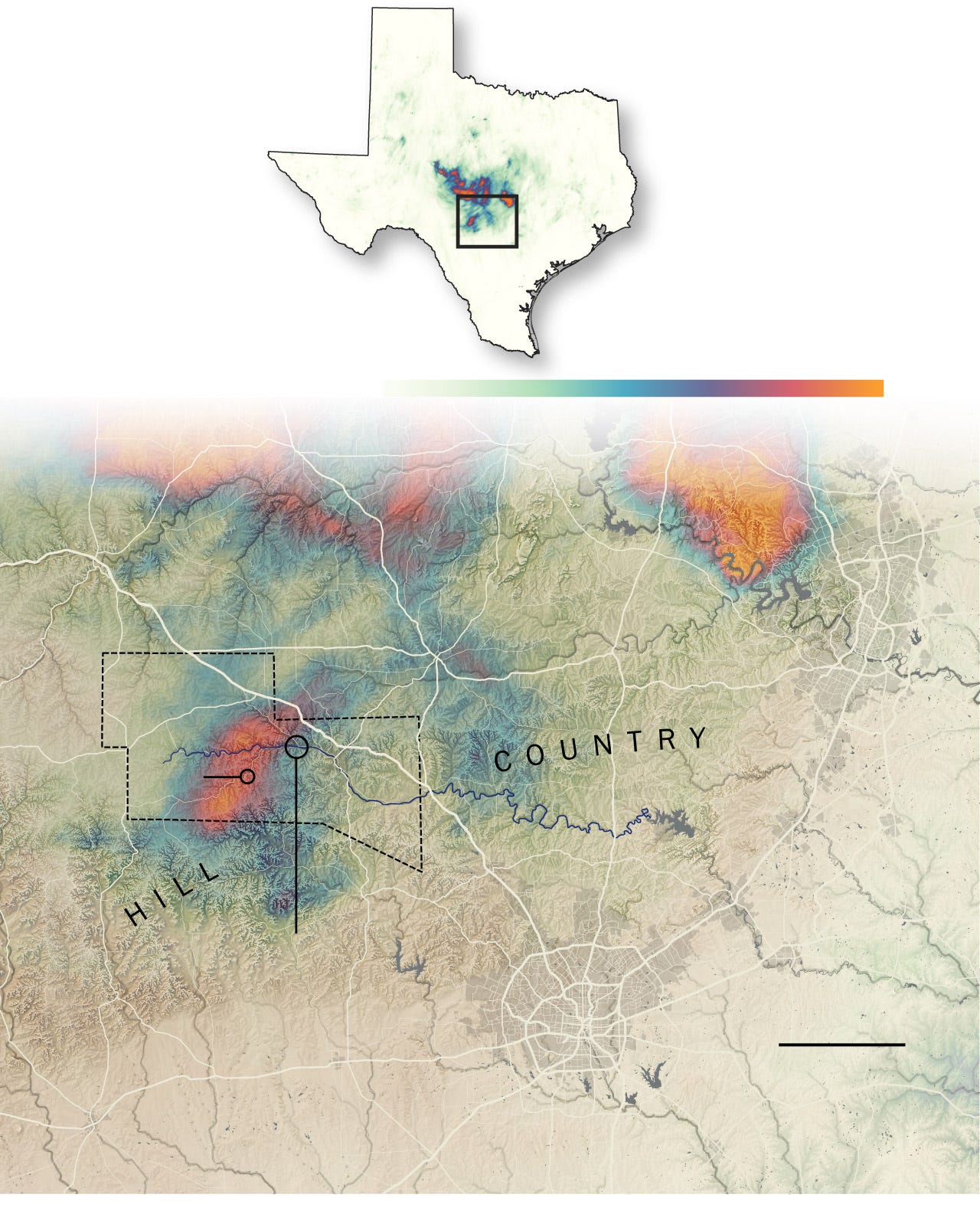
The isolated orange patch in the bottom half of this map shows the area of high rainfall that caused the deadly Kerr County Flood. Why the orange areas in the north part of the map did not cause similar flooding is unknown to me.
More rain fell in the hours that followed, with radar-indicated rainfall totals reaching up to 15 inches across south-central Kerr County.
Why did initial forecasts underestimate rainfall?
Weather forecasting has come a long way, as the improvement in numerical weather models has caused daily forecasts to become much more accurate over the past few decades.
However, as any meteorologist will tell you, forecasting for flooding events is extremely challenging. It’s easy to tell when there will be a chance of flooding over a wide area — hence why flood watches were issued Thursday afternoon, well ahead of Friday morning’s storms. However, it’s extremely difficult to pinpoint exactly where a catastrophic flooding event like this will happen.
Simply put, weather models often struggle with slow-moving mesoscale convective complexes. They’re often relatively disorganized, lack upper-atmospheric support and lack a clear center. These factors make it harder for a weather model to lock in on how a system is moving and evolving.
It’s also near impossible for weather models to predict exactly where the heaviest rainfall bands will set up within a complex of thunderstorms. A few miles can make a huge difference about whether a town gets light rain or a life-threatening flood. On Friday, the bull’s-eye happened to be over south-central Kerr County, causing the Guadalupe River to flood its banks.
[Editor’s note: Remember that during Tropical Storm Allison in 2001, one Houston zip code received three inches of rain overnight while another received 29. The rest of the zip codes fell in between these numbers.
Geographical influences
The Texas Hill Country’s particular geography amplified the flood’s severity. The region features dramatic elevation changes, with steep hills and narrow valleys spread throughout the region. When torrential rain occurs, gravity takes over and causes water to funnel quickly into creeks, rivers, and low-lying areas.
In many areas, these valleys are extremely narrow and winding, which accelerates the flow of water and causes rivers to rise much faster than in flatter terrain. It’s similar to putting your thumb over the end of a garden hose—the narrower the exit, the faster the water shoots out.
The Guadalupe River at Hunt had risen by more than 22 feet over the course of three hours early Friday morning. The river reached its second-highest crest ever recorded.
Compounding the problem is the region’s rocky soil. Much of the Hill Country has very shallow soil layers, situated over limestone or granite bedrock. These rocky layers are nearly impenetrable, so water can’t soak in easily. Because much of the water cannot soak into the ground, the region sees a high percentage of the rainfall become runoff.
All of that water had to go somewhere. By Friday morning, more than a trillion gallons of water had fallen across the region. Much of it surged into the Guadalupe River.
Put everything together — the super-saturated atmosphere, slow-moving thunderstorms, and the geographical factors in place across the Hill Country — and it became the perfect recipe for flash flooding. The Guadalupe River rose by 22 feet in a matter of 3 hours Friday morning, reaching a crest higher than the historic 1987 flood.
A video is worth a thousand words. What a horror.
I have read that Camp Mystic banned cell phones. That makes sense for the kids - to have a time away from the screens - to enjoy camp activities without being drawn into the usual scrum of SM. But...what about staff and senior counselors? There were alerts...
It looks like more of this sort of event will be in our futures. I hope that there will be lessons learned. We have the technology to warn people.
What was the evacuation plan for the camp and was it executed? I worked at a summer camp for several years during college. When we took the kids into a flash flood prone area we all knew what to do and did it, if a storm came. The camp took the possibility of flash floods seriously, planned for them and acted on those plans when necessary.